- Home
- Sailing Authors & Their Writings
- Dr Michael Cohen
- Navigation
Navigation (Part 2)
It's Not Just for the Birds!
by Dr Michael Martin Cohen, M.D.
Navigation with Landmarks and Environmental Cues
Path integration / DR are used when there are no landmarks. On the other hand, if any environmental cue is available it is immediately used. Most animals, including humans, alternate between using landmarks when they are available (“now that I can see that Church spire, I know where I am”) and practicing DR when they are not. For example, the Polynesian navigators spend their youth learning celestial navigation, the wind and current patterns, etc – developing maps in their brain (cognitive maps) but they still depended at times on DR and they were especially good at estimating direction and speed. Here are some of the methods which various animals use to navigate:
Visual Landmarks: We are not the only species that is able to learn landmarks in their environment. Many mammals, birds, and even insects such as ants, bees, and wasps are capable of identifying and using visual landmarks in their navigation. We humans are very dependent on visual stimuli.
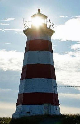 Figure 16: Beacon navigation. When you are navigating to a single location it is referred to as Beacon Navigation. In this case it happens to actually be a beacon.
Echolocation: Many species of bat and even some marine mammals such as dolphins use echolocation for orientation as well as for locating prey. Humans can use sound for localization to a limited extent. See Chapter 2 of Healthy Boating & Sailing for a fuller explanation of the limitations of sound, especially in a nautical environment.
Olfaction: Pigeons are able to navigate in part because of a mental map of odors in their area. Salmon use a magnetic sense to navigate close to their river but then use the sense of smell (olfaction) to identify the river up close. Humans can and do use olfaction in a limited sense and in fact we smell in stereo (like vision and sound) although it doesn’t help in navigation.
Orientation by the Sun: A number of animals navigate using celestial cues including the position of the sun. But, since the sun moves in the sky, there must be some kind of internal clock to compensate for the movement. Animals that use the sun include birds, fish, sea turtles, reptiles, bees, butterflies, and ants. Monarch butterflies use the sun to guide their autumnal migration from Canada to a remote location in Mexico.
Orientation by Polarized Light: Honeybees are a great example of shifting input to whatever is available. If it is sunny, then bees will use the sun and visual landmarks. If overcast, they will switch to polarized sunlight which they can “see” through the clouds.
Orientation by the Night Sky: Many species of bird are able to navigate by the stars (which like orienting to the sun requires some kind of internal clock to use with their built-in sextant. The dung beetle is able to navigate using the polarization patterns of moonlight, bright stars, and even the Milky Way! All of this is accomplished while dancing on the top of a pile of dung.
Magnetoreception: Homing pigeons among many other bird species are able to utilize the magnetic field of the earth – that includes both declination (the angle from magnetic north) and inclination (the dip in the compass needle when the needle is held in a vertical orientation). Homing pigeons will rely on the sun orientation on a clear day but if cloudy will switch to using the earth’s magnetic field. Exactly how this is accomplished is still being worked on.
Unfortunately, we humans are not equipped with most of these cool navigation aids or if we are, they have become vestigial. We are visual creatures for the most part, (unless as Professor Creamer did, we studiously train ourselves to play close attention to all of our other senses). We are always looking for visual landmarks from which to obtain a fix. It could be a landmass, a buoy, the sun or the stars.
Maps in the Brain
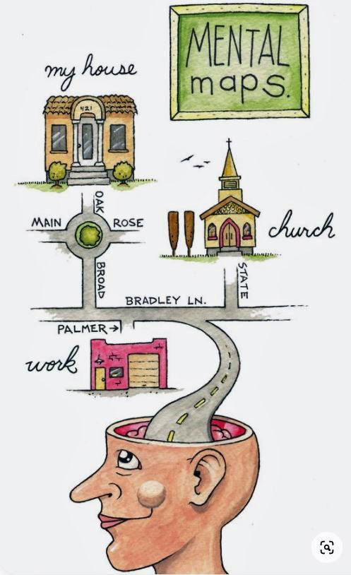 Figure 17: Mental Maps
Navigation studies of different animal species for many decades were basically concerned with animal and human behavior, trying to understand scientifically how various species get around, when by using the sun, stars, or the magnetic field of the earth.
But everything changed in 1971 when John O’Keefe reported on cells in the rat hippocampus that responded to precisely to where the rat was located – the precise place in the box they were running around in – which is why they were referred to as place cells.
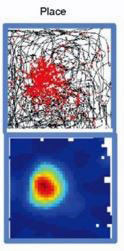 Figure 18: The place cells fire only when the rat is in a certain place in the box
O’Keefe shared the Nobel prize in Physiology or Medicine in 2014. But those discoveries – first of place cells then grid cells and others changed the focus from behavioral navigation research to neurophysiology research – basically navigation and the brain. And the region of the brain which came under the most scrutiny was the hippocampus and the adjacent entorhinal cortex. They are critical for both general memory function and also for performing spatial or mapping within our brain. The hippocampus is responsible for creating a mental map of the environment. Within the hippocampus and its surrounding structures are a number of specialized cells that monitor spatial functions. These specialized groups of cells are like apps that do one thing:
Place cells. The place cells will fire if the rat (or human) goes into a specific place in his or her environment. (Humans have similar place cells but some of the details are still being worked out since humans are more reluctant than rats to have electrodes placed into individual hippocampal cells.) If the rat is in a box or maze, individual place cells will only fire if the rat is in a specific location in the box—for example, see Figure 18. Other cells will only fire if the rat is in the bottom right corner, or the top left corner, and so forth.
Grid cells. These are a different group of cells that are arranged in hexagonal patterns and that keep track of our movement—from place A to place B. They feed information into the place cells to update the current place or location. These grid cells are also capable of keeping time. Direction and time, hmm, if it’s beginning to sound like perhaps the grid cells are an important input to our DR navigation, you would be correct. Except now instead of simply estimating where we are, the grid cells and all the other cells including the spatial view cells are creating a “cognitive map.” The Mosers (husband and wife) shared the Nobel prize with O’Keefe for their discovery of the grid cells. (Figure 19)
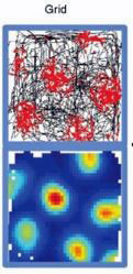 Figure 19: Grid cells arranged in a hexagonal pattern and they will fire as the animal moves from one hexagonal cluster to the next and so it can provide both direction and speed
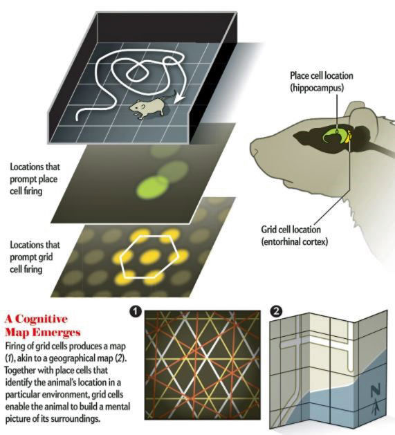 Figure 20: Creation of a "Cognitive Map"
Forward-looking, boundary, and speed cells. These other types of cells only respond when we face a certain direction, or when we get near a boundary—for example a wall or cliff—or when we change speed. This information is sent into the grid cells and other cells, which are then updated and can update the place cells. The forward-looking (head direction) cells function as an “internal compass.” Humans also have grid cells, forward-looking, boundary, and speed cells.
When they looked for these cells in humans (those who were going to undergo epilepsy surgery and needed the electrodes inserted anyway) they found that from an evolutionary point of view, we have not changed all that much from rats. We have place cells and grid cells, and forward-looking cells etc. But we have other cells that they do not have (whew!) including spatial view cells. These are cells that fire only when viewing specific views or landmarks.
All of these specialized cells are critical for creating our cognitive or brain map.
One Way To Think About Human Navigation
No Landmarks or environmental cues à Dead Reckoning / Path Integration
Occasional landmarks or cues à Dead Reckoning / Path Integration with corrective “fix”
Many landmarks or cues à Cognitive Maps
Stable landmarks and same route over and over à Route following [by memory] (below)
Figure 21: Various strategies based on whether or not there are landmarks or other environmental (e.g. celestial) cues. As will be discussed, we are constantly switching from one strategy to another as the need and opportunity arises.
It is not surprising that we have spatial view cells and rats don’t. We are visual creatures and rats are not. And we do have quite a bit more brain power, Figure 22. We have the whole back of the brain devoted to vision (the occipital lobe – both the brain cells on the inside – visible – and those on the outside – not visible) whereas the rat has a tiny oval. In addition, we have specialized groups of cells that respond specifically to faces, others to landmarks, and yet others to landscapes, etc. and the rat does not. He is an olfactory creature and also uses his whiskers to feel through the environment. When we lose our visual sense, we are “lost” but rats can navigate virtually as well even if blind!
Look at the relative sizes of the visual cortex (blue arrows) and then look to the left at the relative size of the olfactory bulb (for smelling). If rats could talk, they would make fun of the small size of our bulb! “How do you smell anything with that!”
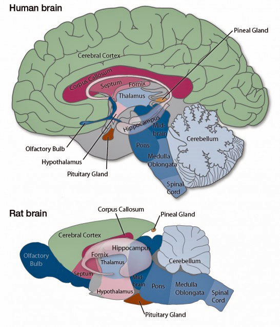 Figure 22: Human versus rat brain. The blue arrows point to the visual cortex.
What about those maps in the brain, so-called cognitive maps? It is important to realize that the cognitive map is not the same type of map as a nautical map or even a GPS map on your digital device. It is topological and attempts to maintain relative relationships between objects, as opposed to maintaining exact relationships. Soon after O’Keefe published his seminal paper, he published a book entitled “The Hippocampus as a Cognitive Map.” His hypothesis is that the hippocampus and surrounding nerve cells were sufficient to form a cognitive map and the hypothesis is very much alive and well although there are still a few final touches that need to be added.
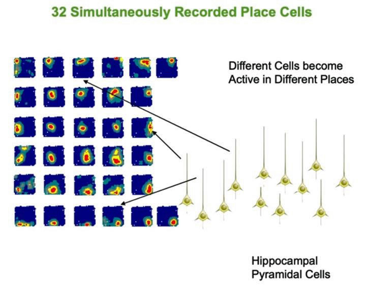 Figure 23: Simultaneous Recorded Place Cells
He has summarized the field in a lecture 29 March 2019 to The Royal Institution which is excellent: How Your Brain Maps The World.
As discussed in Chapter 2 of Healthy Boating & Sailing a colleague of Professor O’Keefe, Professor Eleanor Maguire has demonstrated in taxi drivers that the posterior hippocampus is demonstrably enlarged in those taxi drivers who had passed “The Knowledge” a test of the cognitive map of 25,000 streets and businesses and locations of central London. That is, the neuroplasticity associated with the cognitive maps was so great that it was demonstrable on MRI scan. That’s a lot of knowledge packed into one small brain area (Figure 24).
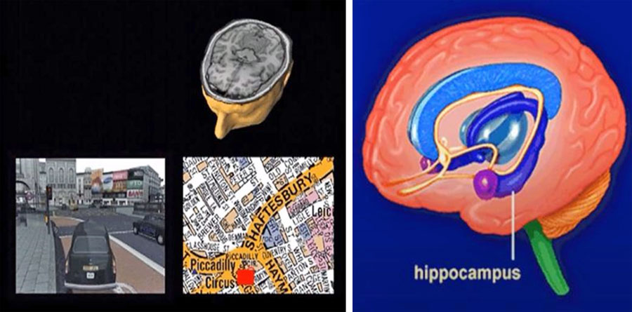 Figure 24: Maguire: London Taxi drivers, and the hippocampus
What examples are there that DR and cognitive maps work together? Probably the best example is Puluwat, southern Pacific Ocean sailors known for their excellent long distant navigation, routinely sailing between islands separated by up to 800 kilometers (500 miles). They use a combination of cognitive maps (based upon knowledge of the sky and sea) and dead reckoning / path integration. In fact, as related by Ekstrom et al 1 the Puluwat spend their first decades in their navigational apprenticeship focusing on two different schools of navigation: Warieng and Fanur. One school is didactic and here the young apprentice learns all of the points on their compass and which stars are located over which compass directions at which time of the year. (Figure 25) They are solely compiling their cognitive map of their island and all of the surrounding islands as well as the rest of their environmental cues, the currents, swells, the dominant wind pattern for that season. All of that goes into their cognitive map. But the second school is the practical school where they lean to hone their sense of direction, estimate their speed, and estimate their distance. That is, they are using both a mapping system and a path integrated system and switching between as needed. Much of the time they probably rely primarily on DR as they are so familiar with the area that they can easily estimate distance and heading.
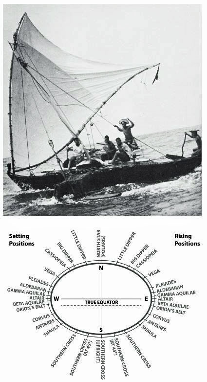 Figure 25: Learning DR (upper picture); learning to map the stars (lower picture)
OK, so all of this could make you a better sailor-navigator, but could it save your life? Absolutely. Consider the classic tale of Shackleton’s Journey. During his expedition to the South Pole, his boat the Endurance became trapped in the ice and lost. Shackleton ordered the expedition to the lifeboats and it took a week to reach Elephant Island (Figure 26) hauling the boats over the ice all the while the ice floes on which the boats were resting moved northward. When they decided to embark in the small lifeboat (Figure 27) named The James Caird, the crew encountered waves as high as 15 meters (50 feet) and wind gusts up to 250km per hour (160 miles per hour). All of the contents of the boat were soaked and frozen, including Frank Worsley’s maps (he was the navigator). The sextant was extremely difficult to use because of wind and waves. He did have a usable compass. Thus, navigation depended almost entirely on Worsley’s DR / internal path integration plus his detailed memory for the positions of the islands in the surrounding Weddell Sea. His DR depended on his estimate of the compass reading, his estimate of distance sailed all the while considering the wind strength, and the sea. It would have been a difficult task with all of his nautical charts and tools.
In this case his memory of the cartographic map served as his cognitive memory but as Ekstrom has pointed out he had never navigated this route before!
 Figure 26: The Voyage of The James Caird
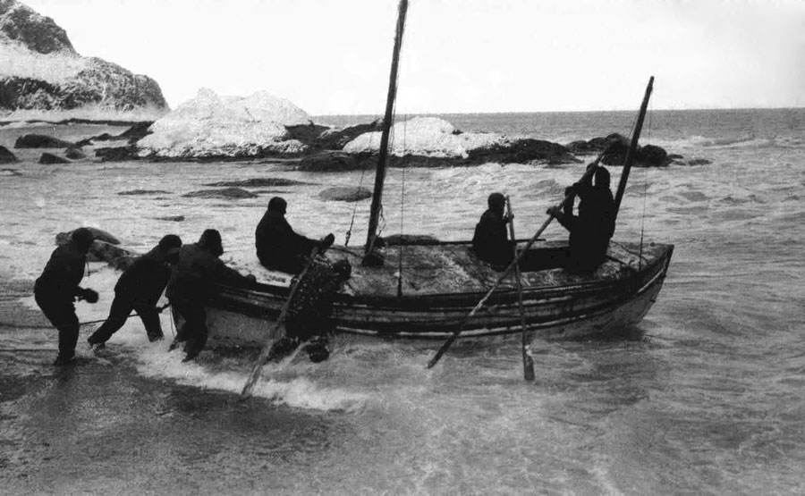 Figure 27: Launching The James Caird
It remains one of the great triumphs of navigation.
So, is that all there is to human (and rat) navigation? Almost. If you glance at Figure 21 the last of the four ways of thinking about navigation is all about following a route. In this case landmarks are everything and one is literally going from landmark to landmark. It is a very inflexible system –unlike all of the other approaches we have been discussing. We can refer to this as the response system.
Think about your routine ride to work. You don’t think in terms of a map, in fact, while driving the same route every day, you don’t think about the route at all. No, you were not using a spatial strategy; rather, you were using a response strategy. What you were responding to were multiple (often unconscious) stimuli (landmarks). It was, in psychologic parlance, a stimulus-response encounter. In reality, multiple stimulus-response encounters. At each point along your route to work, there was a stimulus and you responded. Behind the scenes, so to speak, this type of stimulus response was occurring: “At this traffic light where the gas station is, I need to turn left, and then I continue until I see the McDonalds, at which time I make a right turn.” Or, since we are focused on the water, “When I motor into the harbor, I need to keep the red buoys on my right and the green on my left (“red right returning”). This system depends on a different part of the brain known as the caudate nucleus. This brain structure is very much involved in motor and emotional responses to a stimulus—and often, as in this case, the response or reward may be unconscious.
The beauty of this response system is that it frees up the brain to do other things. It is very efficient. But the downside is that it is very inflexible. All of our other approaches were flexible. So, which is it? It turns out that we humans can and do routinely switch between these systems. The response strategy is quicker and easier—and if possible, we use that system. As everyone is aware, if you drive from your house to work or sail back into your home marina, you basically perform the maneuver on “autopilot”—your brain is responding unconsciously to various landmarks without even thinking about it. We have all had that experience. And it is (generally) very efficient. On the other hand, if we enter a harbor that is new to us, or a new town, we need to consult our charts (or our mental maps) to figure out where we are and how to get to the anchorage or the hotel.
The response system is trained by performing the same sequence over and over.
The point, of course, isn’t that we need to get rid of GPS and “go back to nature.” Rather, the key is to understand how we navigate both on land and at sea and recognize which system we are using. That should motivate you to pay more attention, especially in less well-known waters, to your environment and pick up whatever clues there are. That is, adding an element of “natural navigation.” The clues and landmarks are there. Just pay attention.
The Old Man and the Sea
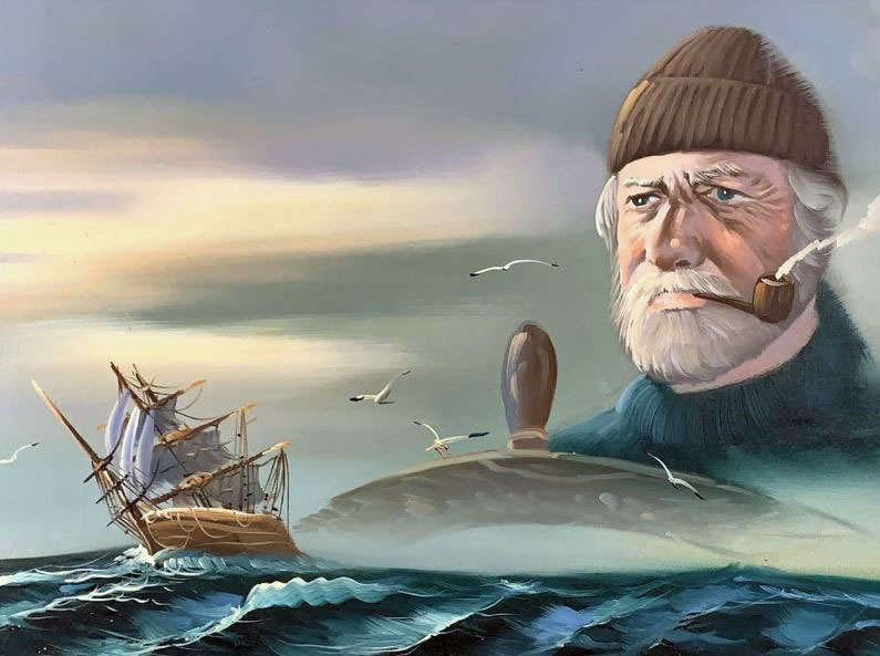 Figure 28: The Old Man and the Sea
I would like to close this second section with a brief discussion of navigation and memory issues that occur with aging and diseases like Alzheimer’s. First of all, it is important to realize that two main functions of the hippocampus are: spatial relationships – especially as regards navigation – and memory which we have not discussed. They are inter-related in ways that are beyond the scope of this discussion. But the following statements are basically true:
1. Many but not all aspects of memory decline with advancing age – in some people more than others.
2. Navigational skills vary quite a bit from person to person – most people think of themselves as below average navigators – but in general navigational skills (both cognitive maps and dead reckoning / path integration) decline slowly with advancing age. Because route following (the response system) does not depend on the hippocampus, I believe that explains the phenomenon whereby older early-stage Alzheimer patients who become lost driving will revert to driving a prior route (for example to work) even though they haven’t been there for many years.
3. As far as the hippocampus is concerned, it enlarges with use (see discussion above concerning the London taxi drivers) and becomes smaller with disuse.
4. There does appear to be such a thing as cognitive reserve (bulking up your brain by challenging it to delay the onset of symptoms).
5. And the corollary – use it or lose it.
So, if navigation skills are lost early, are there any clinical studies of navigational skills? Yes, one of these is referred to as the 4 Mountains test (Figure 29) which is widely used in documenting spatial dysfunction in cases of pre-dementia Alzheimer’s. It is a simple test which correlates with the other studies of early Alzheimer’s. Another is the “Morris Water Maze (not shown).”
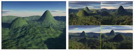 Figure 29: 4 Mountains Test of spatial perception
It should not be surprising that spatial recognition and navigation tests are early predictors since we know that Alzheimer’s Disease starts in the entorhinal area, a part of the hippocampal complex. (see Figure 30).
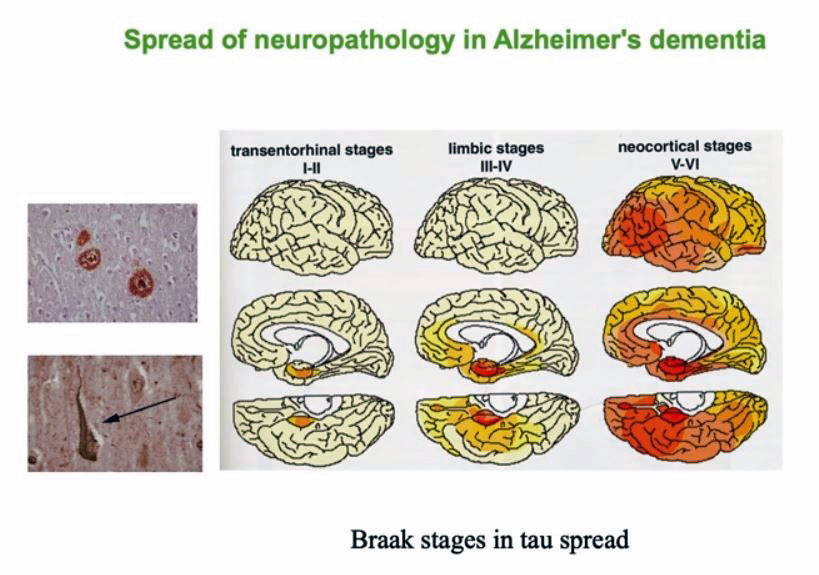 Figure 30: Stages of Alzheimer's dementia. Note the brain to the left has the pathology starting in the entorhinal /hippocampal area and then spreading through the brain
Finally, there has been an ongoing study in Europe called Sea Quest Hero (Figure 31).
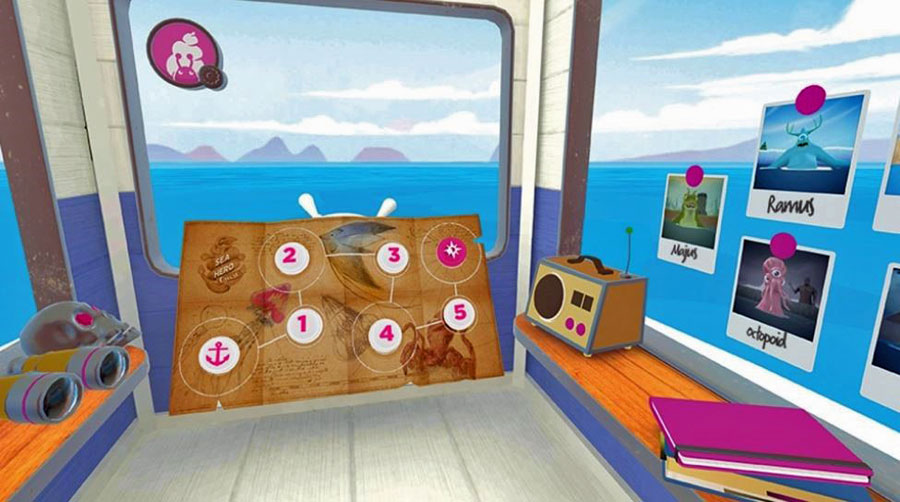 Figure 31: Sea Quest Hero (mobile)
It was developed to analyze navigational abilities and specifically to build a huge database for dementia research. The initial game was a mobile game which tested all aspects of navigation skills including path integration and cognitive mapping. Sea Quest Hero Mobile has been played by over 4 million people providing 117 years of data! The data from the mobile game is in and some of the early results were interesting:
- Differences in basic navigation skill begin to show at around 19 years of age long before other signs of dementia start.
- Men and women employ different strategies to solve puzzles, choosing certain routes over others to complete a level
- People from Nordic countries are better than average (perhaps because they engage in Orienteering)
The data set for the mobile game is closed but it is now available for virtual reality (VR). I have not played it, but it looks cool.2
Dr. Hugo Spiers of University College London who has been leading the analysis of the anonymous player data explained,
“Whilst Sea Hero Quest mobile game gave us an unprecedented data set in terms of its scale, allowing us gauge spatial navigation abilities at a population level, the VR game allows us to build on this by measuring subtle human behavioural reactions with much greater precision.
“With Sea Hero Quest VR we have also been able to replicate highly credible lab-based experiments such as the ‘Morris Water Maze’ (winner of the 2016 ‘Brain Prize’) that would not translate well to video or mobile game format. The intuitive nature of VR means that the study can be opened up to those who might not be able to grasp the function of the mobile game – some people with advanced dementia for example.”
The loss of navigational skills may turn out to be the earliest predictor of dementia: perhaps identifying cases decades before symptoms, allowing earlier treatment before there is much accumulated damage.
1 Ekstrom et al. Human Spatial Navigation 2018
2 https://youtu.be/Prpm9ZtAPXU
Recent Articles
-
Modern Boat Electronics and the Latest Marine Instruments
Dec 20, 25 05:27 PM
Should sailboat instruments be linked to the latest boat electronics as a fully integrated system, or is it best to leave them as independent units? -
Hans Christian 43: Classic Bluewater Cruiser & Liveaboard Sailboat
Dec 10, 25 04:37 AM
Explore the Hans Christian 43: a legendary heavy-displacement, long-keel sailboat. Read our in-depth review of its specs, design ratios, and suitability for offshore cruising and living aboard. -
Planning Your Sailboat Liveaboard Lifestyle: An Ocean Sailor's Guide
Dec 06, 25 05:18 AM
Seasoned sailors share their methodical risk analysis for planning a secure Sailboat Liveaboard Lifestyle, covering financial, property, and relationship risks.
