- Home
- Electronics & Instrumentation
- Marine AIS System
You'll Never Regret Installing a Marine AIS System
There are times when a marine AIS system can be enormously useful. Take the following scenario...
 "Westbound motor vessel two miles south of St Catherines Point, this is the eastbound sailboat 'Apprehensive' one mile off, fine on your port bow. Over"
Absolutely nothing...
"Did he hear us?"
"Does he know we mean him?"
"Is anyone on watch?"
"Is he going to change course?"
"Do we need to change course to starboard now or should we stand on until we see what he does?"
Annoyingly, such one-sided VHF communications between sailboats and merchant vessels are all too common.
An AIS receiver could have told us a great deal about this vessel; but how and what?
What Is the Marine AIS System?
AIS (Automatic Identification System) is a new aid to collision avoidance operating on two dedicated VHF channels. There are three types of AIS instruments:
- AIS Transponders that transmit and receive, and
- AIS Receivers, which do just that (and only that), and
- AIS Lifejacket Transmitters
But before we dive deeper into these, let's talk about how AIS systems are increasingly integrated into modern navigation technology.
Today, AIS can pair seamlessly with GPS systems, radar, and multifunction displays (MFDs). Combining AIS data with these tools provides an exceptional level of situational awareness, allowing sailors to detect and track vessels that may not be transmitting AIS signals.
This integration makes the marine AIS system a vital companion for navigating busy waterways or low-visibility conditions.
Marine AIS Transponders
There are two types of AIS transponders: Class A and Class B.
Class A Transponders are designed for commercial vessels and are mandatory for ships of 300 tonnes and above. These units transmit detailed data every 2 to 10 seconds while underway, including:
- Position, speed over ground, and course.
- The vessel's unique MMSI number and IMO ship identification number.
- Its name, call sign, and destination.
Class A units require up to 12.5 watts of power, giving them a much greater range than their Class B counterparts.
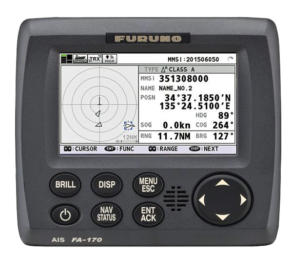 A Class A Transponder
Class B Transponders, intended for smaller vessels like sailboats, transmit less data and operate at a lower power level (2 watts), with an effective range of 5 to 10 miles.
While Class B units are more affordable, they don’t broadcast information like the vessel's IMO number or estimated time of arrival, which could be a limitation for some users.
Including this feature in the text would help readers understand the practical trade-offs between Class A and Class B units.
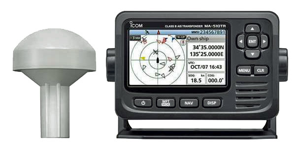 A Class B Transponder
Marine AIS Receivers
AIS receivers display information about nearby vessels but don't transmit data, making them ideal for sailors who want a cost-effective solution for collision avoidance.
When paired with a chartplotter, AIS receivers offer a seamless navigation experience: arrows indicate vessel speed and direction, bars show rate of turn, and hovering over a ship’s icon reveals detailed data.
AIS receivers integrate beautifully with modern chartplotters, providing an efficient way to monitor other vessels in real-time—without needing a separate VHF antenna splitter if you choose DSC VHF radios with built-in AIS capabilities. This is an excellent feature for sailors who want simplicity and performance combined.
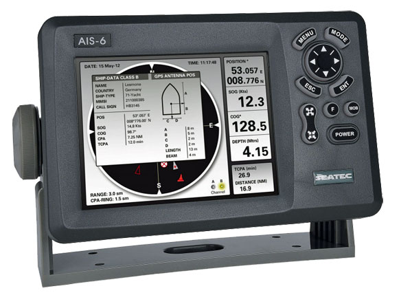 An AIS Reciever
An arrow will show direction of travel (the longer arrow the faster the vessel is moving), a bar on the arrow shows if the vessel is turning and which way. Hover over the ship's position with the cursor and all the vessel-related data will come up.
I can remember a number of English Channel crossings in poor visibility when I would have paid handsomely for one of these. You're immediately aware of all ships' movements around you, course changes are shown pretty much instantly - much faster than radar.
No need to call "Westbound vessel two miles south of St Catherines Point etc...." now. You've got his name, callsign, MMSI number, inside leg measurement, the lot.
AIS Lifejacket Transmitters
If you're unfortunate enough to fall over the side, particularly at night in lively conditions, you will soon be lost from sight and your chances of rescue are slim indeed.
However, with one of these small devices—also known as PLBs (Personal Locator Beacons) attached to your lifejacket the likelihood of rescue are dramatically improved.
Providing your mothership - or any other vessel within a four mile range - has an AIS receiver your exact position will show up on screen.
But...
While AIS provides tremendous benefits, it's not foolproof. For example, vessels can appear "At Anchor" while moving at 12 knots, so it's always wise to cross-reference AIS data with other navigation tools like radar or visual observations.
Maintenance is also vital to ensure your AIS system remains reliable. Regularly check the VHF antenna connections for corrosion, keep the software updated, and test the system periodically. These small steps can go a long way in avoiding unexpected failures during critical moments.
Cost and Installation Insights
Cost is often a deciding factor for sailors when choosing an AIS system. Class A transponders, while powerful, can cost over $3,000, whereas Class B units and AIS receivers are more affordable options for recreational sailors.
Installation can be straightforward, but challenges like antenna placement or compatibility with chartplotters may arise. Consulting the manufacturer’s guidelines or seeking professional assistance can save time and ensure optimal performance.
Environmental Impact
The Marine AIS System doesn’t just improve safety—it also contributes to responsible maritime practices. By providing real-time data, AIS helps vessels navigate efficiently, avoid marine protected zones, and reduce fuel consumption. For environmentally conscious sailors, this feature underscores AIS as a tool for sustainable navigation.
And finally...
If you want other vessels to know you're out there, fit a Class B transponder. It’s more expensive than a receiver but makes AIS-equipped ships aware of your position, course, and speed. And for those venturing into areas where invisibility is the wiser course, Class B units can be switched to receive mode only.
An AIS unit is truly a game-changer for sailors—it combines advanced technology, affordability, and safety into one invaluable package. Whether you’re navigating busy shipping lanes, crossing foggy waters, or planning your next voyage, AIS is the essential tool you won’t regret investing in.
Marine AIS Issues: Your Questions Answered...
Recent Articles
-
The Marine AIS System
Apr 03, 25 09:30 AM
What si the Marine AIS System is, how does it work and what can it do for us sailors? -
Marine AIS Issues: Your Questions Answered
Apr 03, 25 04:16 AM
Got a marine AIS issue? Odds are you'll find the answer here... -
Beneteau Oceanis 36CC Sailboat Specs & Key Performance Indicators
Apr 02, 25 10:09 AM
The Beneteau Oceanis 36CC sailboat specs and KPIs set out here say a lot about how this centre-cockpit sloop is likely to behave in a seaway...
