- Home
- Electronics & Instrumentation
- Gmdss System
The GMDSS System - What is it?
The Global Maritime Distress & Safety System (or the GMDSS System for short) was developed by the International Convention for the Safety of Life at Sea (SOLAS).
Rightly concerned with the limitations of distress calls via VHF - short range, manual alert and dependency on aural watchkeeping - SOLAS called for the development of a more efficient approach to distress situations using modern technology and automation.
As a result of the implementation of the GMDSS system, the 2182kHz listening watch aboard SOLAS ships ended on 1st February 1999 and the VHF Ch16 watch ended on 1st February 2005, since which the coastguard no longer has had a dedicated headset watch.
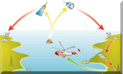
The GMDSS system involves geostationary satellites (INMARSAT ), Coastguard Shore Stations and Rescue Coordination Stations and it's this system that swings into action when the distress button is pressed on your DSC (Digital Selective Calling) enabled VHF radio.
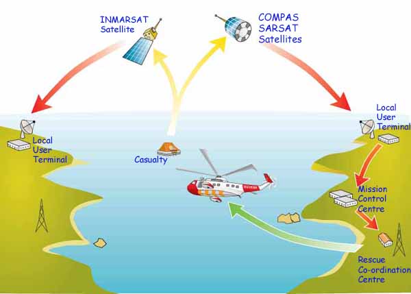 The key components of the Global Maritime Distress & Safety System (GMDSS)
The GMDSS system incorporates a number of sub-systems, of which DSC is just one. Others include
- Satellite Communication;
- the Maritime Safety Information (MSI) system;
- NAVTEX;
- the Search & Rescue Transponder (SART) system.
Satellite Communication as part of the GMDSS System
INMARSAT, the fully commercial non-government satellite network supporting GMDSS also provides a communication system accessible by dedicated mobile handsets (satphones).
INMARSAT, founded in 1979, is the oldest satellite phone operator but other networks are now in place and operating. Of these, GLOBALSTAR and IRIDIUM are those most used by yachtsmen.
Satphones, once the size and weight of a building block are now much like mobile phones, but rather more expensive. Outgoing calls from satellite phones to landlines and mobile phones are reasonably inexpensive, currently from around $0.15 to $2 per minute.
Calls made from landlines and mobiles to satellite phones are very expensive for the caller - around $3 to $14 per minute - but free for the receiver. Making calls between different satellite phone networks is also notoriously expensive with calling rates of up to $15 per minute.
The Maritime Safety Information (MSI) System
This system provides navigational and meteorological information, plus other urgent safety-related information such as electronic chart correction data.
MFI is broadcast through two independent systems - MF telex (NAVTEX) for local MFI and by satellite or HF telex (SafetyNET) for long-range MSI.
NAVTEX
The NAVTEX installation aboard sailboats normally comprises a receiver with a built-in printer and an external antenna, although there are a number of paperless units available which displays the information on a scroll-down screen.
Typical range is up to 400nM. Two frequencies are used - 518kHz (international frequency) and 490kHz (national frequency), and being a line of sight system, NAVTEX may be difficult to receive when there's an obstruction between the transmitter and your antenna.
NAVTEX transmissions are sent in English language from local stations situated worldwide. The power of each transmission is regulated so as to avoid the possibility of interference between transmitters.
NAVTEX receivers can be programmed to receive specific message and reject others - ice reports for example being unlikely to feature strongly in the Caribbean. But navigational and meteorological warnings, and search and rescue information are non-rejectable to ensure that vessels equipped with NAVTEX always receive the most vital information.
Search & Rescue Transponder (SART) system
A SART, normally present on ships rather than cruising yachts, is a portable radar transponder intended for deployment from a liferaft. It will transmit a homing signal which shows up on the radar displays of ships and aircraft involved in a search and rescue mission as a series of 12 dots, indicating the required course setting to the casualty.
Sea Area Classifications
Understanding GMDSS sea areas is crucial for sailors. These areas determine the type of equipment required based on coverage:
- Area A1: Coastal coverage with VHF DSC capabilities, typically extending 20–30 nautical miles.
- Area A2: Medium Frequency (MF) coverage, reaching up to 180 nautical miles offshore.
- Area A3: Global coverage between 70°N and 70°S, supported by satellite communication like INMARSAT.
- Area A4: Polar regions requiring High Frequency (HF) communication due to satellite limitations.
Knowing your operating area ensures you’re equipped with the right tools for distress communication.
Testing & Maintenance
Regular testing and maintenance of GMDSS equipment are essential to ensure functionality during emergencies. For instance:
- EPIRBs should undergo annual testing to verify battery life and signal transmission.
- DSC radios require periodic checks to ensure proper connectivity and alerting capabilities.
- NAVTEX receivers should be tested for message reception and display clarity.
A proactive approach to maintenance can prevent equipment failure when it’s needed most.
Training & Certification
Operating GMDSS equipment requires specialized training and certification. Courses like the General Operator’s Certificate (GOC) prepare sailors to use the system effectively.
Training covers everything from distress alerting procedures to equipment testing. Certification ensures that operators are competent and compliant with international standards.
Cost Analysis
The financial aspect of GMDSS cannot be overlooked. Equipment costs, subscription fees for satellite services, and maintenance expenses can add up. For example, satellite communication costs range from $0.15 to $15 per minute, depending on the network and call type.
Sailors should budget for these expenses and explore cost-effective options, such as shared satellite plans, regional service providers—or maybe Starlink...
Starlink Maritime: Connectivity for Cruising Sailors
Staying connected at sea is increasingly important for cruising sailors, whether for navigation, weather updates, or keeping in touch with family. SpaceX's Starlink Maritime offers a groundbreaking solution with high-speed internet powered by a constellation of small satellites in low Earth orbit (LEO).
Unlike traditional systems, Starlink provides faster speeds, lower latency, and broader coverage—even in remote locations.
What Starlink Maritime Offers
Starlink delivers download speeds between 40 Mbps and 220 Mbps, with latency as low as 20ms. Its Flat High-Performance Starlink dish is engineered for harsh maritime environments, ensuring reliable connectivity in most conditions. The service is particularly useful for crew communication, real-time weather updates, and even remote monitoring of vessel systems.
For adventurous cruisers, it supports scientific exploration and research with dependable data transfer capabilities.
How Starlink Maritime Compares to GMDSS
While Starlink excels in internet connectivity, it doesn't replace the Global Maritime Distress & Safety System (GMDSS), which is a mandatory safety system for distress communication and rescue coordination. Starlink is an optional service, focused on convenience and enhancing quality of life onboard, while GMDSS ensures safety compliance.
Considerations for Cruising Sailors
Starlink Maritime comes with a higher cost, starting at $250 per month, alongside upfront installation fees. Additionally, signal stability can be affected on moving vessels, though its robust hardware is designed to counter these challenges.
While it’s not a replacement for safety systems, Starlink complements them by providing reliable connectivity for everyday needs.
For cruising sailors, Starlink Maritime represents a significant upgrade in how life at sea is experienced, offering the tools to stay connected, informed, and efficient during voyages.
It’s an investment in both convenience and innovation that aligns perfectly with the adventurous spirit of life at sea.
GMDSS for Cruising Sailors: Your Questions Answered...
Recent Articles
-
Passoa 47 Sailboat Review: Comprehensive Specs & Performance Analysis
Jan 04, 26 04:57 AM
Discover the Passoa 47, a legendary aluminium blue water cruiser by Garcia. Explore technical specifications, design ratios, and why its lifting keel is a game-changer for offshore sailors. -
Sailboat Wheel Steering Maintenance & Inspection Checklist
Dec 30, 25 02:32 PM
Keep your vessel’s helm responsive and reliable with our expert maintenance checklist. Master cable tensioning and system inspections to avoid mid-passage failures. -
Modern Boat Electronics and the Latest Marine Instruments
Dec 20, 25 05:27 PM
Should sailboat instruments be linked to the latest boat electronics as a fully integrated system, or is it best to leave them as independent units?

