- Home
- Electronics & Instrumentation
- Marine EPIRB
- What Is a Chartplotter
What is a Chartplotter: Your Questions Answered
A chartplotter is an electronic navigation device used to assist sailors and fisherman in plotting courses and navigating inshore and offshore waters. It integrates GPS data with electronic navigational charts to display a vessel's position, heading, and speed in real-time.
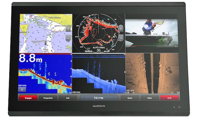 The Garmin GPSMAP 8400 is a high-end marine chartplotter
Frequently Asked Questions about Chartplotters:
How accurate is the GPS positioning in various weather conditions?
How accurate is the GPS positioning in various weather conditions?
Marine GPS chartplotters are highly accurate, often providing positioning within a few meters. However, accuracy can be influenced by factors such as satellite availability, signal interference, and weather conditions. For recreational sailors, this means that while the chartplotter is reliable in most scenarios, dense cloud cover or storms might slightly reduce accuracy.
To mitigate this, many devices incorporate technologies like WAAS (Wide Area Augmentation System) or EGNOS (European Geostationary Navigation Overlay Service), which enhance precision.
It's also worth noting that having a backup navigation method, like paper charts or a handheld GPS, is a prudent choice for safety
Can the chartplotter handle long-distance navigation without signal loss?
Can the chartplotter handle long-distance navigation without signal loss?
Yes, modern chartplotters are designed to maintain a stable connection to multiple satellites, ensuring reliable long-distance navigation. Recreational sailors embarking on extended voyages can benefit from devices with multi-channel GPS receivers, which reduce the risk of signal loss.
Additionally, some chartplotters support GLONASS or Galileo satellite systems alongside GPS, providing even greater coverage and redundancy. For those sailing in remote areas, investing in a chartplotter with these capabilities is highly recommended.
Is the chartplotter interface user-friendly for quick adjustments during sailing?
Is the chartplotter interface user-friendly for quick adjustments during sailing?
User-friendly interfaces are a hallmark of modern chartplotters. Touchscreen models with intuitive menus and customizable layouts make it easy for sailors to adjust settings, plot routes, or set waypoints on the fly.
For recreational boaters, this means less time spent navigating the device and more time enjoying the journey. Some chartplotters also offer physical buttons or knobs, which can be useful in rough seas when touchscreens might be harder to operate.
Are there customizable settings for specific sailing needs?
Are there customizable settings for specific sailing needs?
Most chartplotters allow users to tailor settings to their specific needs. For example, sailors can set alarms for shallow waters, obstacles, or deviations from a planned route.
Recreational boaters might also appreciate features like night mode for low-light conditions or the ability to display only the most relevant data on the screen. Customizable overlays, such as wind speed, depth, and tide information, can further enhance the sailing experience.
Can the chartplotter integrate with autopilot systems or radar?
Can the chartplotter integrate with autopilot systems or radar?
Integration with other marine electronics is a key feature of many chartplotters. For recreational sailors, this means the ability to connect the chartplotter to an autopilot system, allowing for automated navigation along a pre-set route.
Integration with radar can provide additional safety by displaying nearby vessels or obstacles directly on the chartplotter screen. These features are particularly valuable for those who sail solo or in challenging conditions.
Does the chartplotter support AIS (Automatic Identification System) for tracking nearby vessels?
Does the chartplotter support AIS (Automatic Identification System) for tracking nearby vessels?
AIS compatibility is a common feature in modern chartplotters, enabling sailors to track nearby vessels and avoid collisions. For recreational boaters, this is especially useful in busy waterways or during night sailing.
AIS data typically includes information about a vessel's name, speed, direction, and proximity, all displayed on the chartplotter screen. Some devices also allow users to set alarms for vessels entering a defined safety zone.
How often are the charts updated, and is there a subscription fee?
How often are the charts updated, and is there a subscription fee?
Chart updates are crucial for safe navigation, as they include changes to waterways, new hazards, and updated depth information. Most chartplotters offer regular updates, which can be downloaded via Wi-Fi or a computer.
Recreational sailors should check whether their device requires a subscription for updates, as some brands offer free updates while others charge an annual fee. Staying current with updates ensures accurate and reliable navigation.
Are updates easy to install while onboard?
Are updates easy to install while onboard?
Installing updates is generally straightforward, especially with chartplotters that support over-the-air updates via Wi-Fi. For recreational sailors, this means updates can often be completed while docked or even at sea, provided there is an internet connection.
Devices without Wi-Fi may require updates to be downloaded onto a USB drive or SD card, which can then be inserted into the chartplotter.
Is the chartplotter waterproof and resistant to saltwater corrosion?
Is the chartplotter waterproof and resistant to saltwater corrosion?
Marine GPS chartplotters are built to withstand harsh environments, with most models being waterproof and resistant to saltwater corrosion. For recreational boaters, this means the device can handle splashes, rain, and even occasional submersion without damage. It's still a good idea to check the IP rating of a chartplotter, as higher ratings indicate better protection against water and dust.
How does the chartplotter perform under extreme temperatures?
How does the chartplotter perform under extreme temperatures?
High-quality chartplotters are designed to operate in a wide range of temperatures, making them suitable for use in both hot tropical climates and cold northern waters.
Recreational sailors should consult the manufacturer's specifications to ensure the device meets their needs, especially if they plan to sail in extreme conditions.
What is the chartplotter power draw, and can it run on solar or battery systems?
What is the chartplotter power draw, and can it run on solar or battery systems?
Power consumption varies by model, but most chartplotters are energy-efficient. Recreational sailors using solar panels or battery systems will find many devices compatible with these power sources. It's important to calculate the total power draw of all onboard electronics to ensure the energy supply is sufficient for extended trips.
Does the chartplotter offer route planning and waypoint management?
Does the chartplotter offer route planning and waypoint management?
Route planning and waypoint management are standard features in most chartplotters. Recreational sailors can use these tools to plot courses, mark points of interest, and optimize navigation.
Advanced devices may also offer features like automatic route generation based on user preferences or real-time adjustments for changing conditions.
Are there advanced features on the chartplotter like weather overlays or tide predictions?
Are there advanced features on the chartplotter like weather overlays or tide predictions?
Many modern chartplotters include advanced features such as weather overlays, tide predictions, and current data. For recreational sailors, these features provide valuable insights for planning trips and avoiding adverse conditions.
Some devices also integrate with weather services to provide real-time updates, which can be a game-changer for safety and convenience.
What are common chartplotter issues, and how can they be resolved quickly?
What are common chartplotter issues, and how can they be resolved quickly?
Common issues with chartplotters include software glitches, outdated charts, and connectivity problems. Recreational sailors can often resolve these by updating the software, checking connections, or consulting the user manual. Having access to reliable customer support and keeping a backup navigation method can also help address problems quickly.
Is there reliable customer support available for technical problems?
Is there reliable customer support available for technical problems?
Most reputable manufacturers offer reliable customer support, including online resources, helplines, and service centers. Recreational sailors should consider brands known for excellent after-sales service, as this can make a significant difference in resolving technical issues.
Does the chartplotter work with different brands of marine electronics?
Does the chartplotter work with different brands of marine electronics?
Compatibility with other marine electronics depends on the chartplotter's connectivity options. Devices with NMEA 2000 or similar standards are more likely to work seamlessly with equipment from different brands. Recreational sailors should ensure their chartplotter is compatible with their existing setup to avoid integration issues.
Can the chartplotter connect to mobile devices for remote control or monitoring?
Can the chartplotter connect to mobile devices for remote control or monitoring?
Many chartplotters can connect to smartphones or tablets via Wi-Fi or Bluetooth. For recreational sailors, this means the convenience of remote control, monitoring, and even route planning from a mobile device. Some apps also allow for data sharing between the chartplotter and mobile devices, enhancing functionality.
Are there budget-friendly chartplotter options with essential features?
Are there budget-friendly chartplotter options with essential features?
Yes, there are budget-friendly chartplotters that offer essential features like GPS positioning, route planning, and basic charting. These models are ideal for recreational sailors with smaller boats or those who don't require advanced functionalities. Comparing reviews and specifications can help identify the best options within a given budget.
Recent Articles
-
How a Marine EPIRB Can Get You into Trouble, As Well As Out Of It
Apr 12, 25 08:50 AM
Activating a marine EPIRB or a Personal Locator Beacon (PLB) when you're not in distress can get you in big trouble with the Coastguard, as this cautionary tale relates. -
What is a Chartplotter? Your Questions Answered
Apr 12, 25 04:48 AM
Got any questions about marine GPS chartplotters? Odds are, you'll find your answer here... -
The GMDSS System; What Is It and What Does It Do?
Apr 10, 25 04:09 PM
Were it not for the GMDSS System we sailors would have no DSC, SATCOM, MSI, NAVTEX, EPIRB or SART Systems. If that leaves you none the wiser, read on
